
A Tale of Two Cities
Part 1
What the closing of Mount Royal to through traffic symbolizes to some Montreal Islanders
By Wanda Potrykus
The story begins…
“It was the best of times, it was the worst of times, it was the age of wisdom, it was the age of foolishness, it was the epoch of belief, it was the epoch of incredulity, it was the season of Light, it was the season of Darkness, it was the spring of hope, it was the winter of despair, we had everything before us, we had nothing before us, we were all going direct to Heaven, we were all going direct the other way…”
A Tale of Two Cities, Charles Dickens, Book I, Chapter 1, The Period.
A new vision…
On a mountain, on an island in the middle of one of the world’s longest rivers over the span of less than two hundred years two great cities grew into being, one for the living, the other for the dead. Although the City of the Living dates its founding from 375 years ago, it wasn’t truly a city then, more like a small settlement that eventually expanded to become the city it now is.
As for the City of Dead, it only came into being one hundred and sixty-five or so years ago, in this particular location at least, as indigenous people had been burying their dead on the mountain in various locales for many years before these two cities grew to the size they are now.
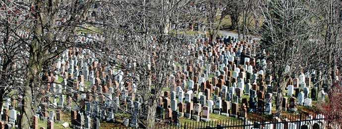
Mount Royal cemetary – Image: shankar s. via StockPholio.net
Physically separated 60+ years ago by a roadway that was previously tram-tracks for 30 or so years before that, these two mountain metropoles face one another across what has recently become a hotly contested symbolic strip of asphalt with rumours, half-truths and wild and unwelcome ideas abounding. Representing as they do both life and the afterlife, the cities also symbolize, each in its own way, the heartaches and the heart of an island with its namesake central mountain; which is being torn apart by what some residents see as an cynical, ignorant and unfeeling abuse of power by the ruling political party at City Hall, who wish to close the mountain to through traffic citing opportunistic “serious safety” concerns.
We’ll consult after we’ve closed the mountain to through traffic.
Valérie Plante, Mayor of Montréal
Pitting citizen against citizen, cyclists and pedestrians against motorists, public transit against private transportation owners, commuters against recreationists, politicos against the proletariat, the young, the fit and healthy against the very young, the old, the disabled, the infirm and the physically challenged. What a perfect storm of emotion and irrationality we are bearing witness to in this, the second decade of the 21st century. Welcome to life on Montreal Island under the Projet Montréal administration and its misguided, heavy-handed efforts at social engineering.
“It equates to social engineering, telling people how they’re going to live. And it’s not going to really reduce the number of cars on the mountain, it’s going to increase the number of cars around the mountain – Cote des Neiges Rd., Pine Ave., Park Ave., what have you.”
Jennifer Crane, Montrealer
Our mountain isn’t really a mountain but a hill
Not really a mountain at all, and not an extinct volcano either, but the eroded remains of a hill with three defined summits, Montreal island’s Mount Royal has loomed large in the mostly flat, glaciofluvial plains of the area since its formation 125 million years ago when lava in the earth’s core burst through the Canadian Shield (composed of Precambrian igneous and high-grade metamorphic rock) as a result of a travelling geological phenomenon known as the New England Hotspot. (And, no, however catchy, it’s not the name of mobile night club.)
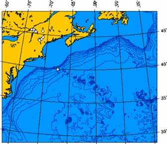
New England hotspot intrusions – westernmost white dot is Mount Royal – Image: Public Domain
The resulting intrusion or bubble (blister) from a geological perspective is neither, as some have incorrectly supposed, part of the Laurentian Mountains to the north and/or the Adirondacks nor the Appalachian Mountain chain to the southeast, but belongs instead to the somewhat more unusual Monteregian Hills formations scattered on the south-eastern fluvial plains, or lowlands of the St Lawrence river that stretch almost as far as the Québec-Maine-New Hampshire border.
The Monteregians (aka Montregians) are butte-type igneous rock formations, also referred to in North America as monadnocks (and as inselbergs in other parts of the world), which is a word of Native American origin, and means a solitary hill rising above the flat area surrounding it. The Montregians stretch east from the island of Montréal for 80 km (about 50 miles).
Most of them are characterized by high crests or buttes on their northeast sides and gradual slopes on their southwest sides as demonstrated by the other hills in the classic Montregian formation that extend eastwards on the south shore of the St Lawrence into Quebec’s Montérégie and Estrie regions, where the “mountains” of Saint-Bruno, Saint-Hilaire (Beloeil), Saint-Grégoire (Johnson), Brome, Rougemont, Yamaska, and Shefford, are found.
‘Although for the most part collectively referred to as Mont Royal, Montreal’s mountain actually consists of three distinct peaks…’
Mont Mégantic is also considered, by some geologists, to be a part of this grouping of hills, as the most easterly and last of our local series of modnadnocks; however, it does not quite share the “classic” form of the others being much larger with four distinct peaks, of which Mont Mégantic is the highest at 1105 m.
Although for the most part collectively referred to as Mont Royal, Montreal’s mountain actually consists of three distinct peaks: Mont-Royal (also known as the Colline de la Croix), which is the tallest at 233 m (764 feet), followed by Mount Murray or Colline d’Outremont or Colline de Côte-des-Neiges at 211 m (692 ft) and the Westmount Summit or “Little Mountain”, which is the smallest of the three summits at 201 m (659 ft) above sea level.
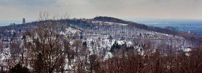
Outremont Summit as seen from Mount-Royal Summit – Image: Owen Byrne via StockPholio.net
A summit with many names
Confusingly enough, the Outremont peak is often referred to as Mount Royal’s third summit, even though it is its 2nd in terms of actual height. It’s also the less well known and possibly somewhat less utilized of the three, especially in terms of access by most Montrealers. Except, of course, during the years the Université de Montréal offered access to a toboggan run, a ski jump and a ski slope with a rope pull and later a T-bar lift.
Today, it’s predominantly mountain bikers who flock there (and who build and rebuild their trails to the detriment of the vegetation and the natural water runoff), as well as local photographers and those who hike up it, both with and without their dogs, trying not to get rundown by the bikes.
In addition, in June 2017, during Montréal’s 375th anniversary celebrations, the city formally renamed the Outremont peak yet again (as it seems to be the summit that has had the most names attached to it over the years). Thus, it is now to be known as Parc Tiohtià:ke Otsira’kéhne, which is a Kanien’kehá:ka (aka Haudenosaunee, Mohawk or People of the Flint) name for “the place of the big fire”. The gesture was made in commemoration of how the hill had traditionally been used in earlier times as a site for beacon or signal fires used by First Nations people for warnings, or to signify gatherings, although it’s not actually clear if they used that peak exclusively and/or either of Mount Royal’s two other peaks for their signal fires.
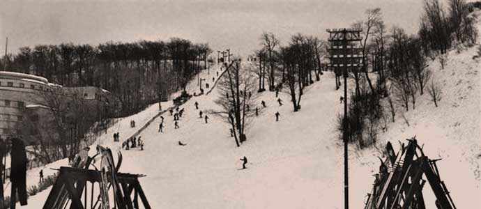
The Mount Royal ski hill behind Université de Montréal on January 4, 1979 – Image: Université de Montréal archives
Now, all we have to do is to learn how to properly pronounce the new name; apparently Tiohtià:ke Otsira’kéhne = djodjâgué otchira’guéné in French phonetics and pronounced jojagay ochira’gaynay in the corresponding phonetical English pronunciation; however, I haven’t yet mastered how to make it roll off my tongue without faltering halfway through, but, as always, practise should eventually make perfect.
Which indigenous peoples lit the signal fires?
The complete history of the former inhabitants of Montreal Island has yet to be definitively written and probably won’t be any time soon but, from all the conflicting information available, there seems to be a fair amount of revisionist history going on as the years pass, but that’s a story for another time.
What we do know with some certainty is that approximately 10,000 years ago with the receding glaciers and the eventual draining of the shallow Champlain Sea that used to occupy the area between the St Lawrence and Ottawa River valleys, the island of Montreal was exposed, thus making the area habitable over time for some of the continent’s earlier human inhabitants to move onto and travel across. Who they were, and where they came from is still up for some debate, with conflicting opinions abounding.
Hochelaga – Whose home?
However, by the time Jacques Cartier first visited in 1535, there were an estimated 1,500-3,000 people living in the fortified settlement on the island that he referred to as Hochelaga, although there continues to be uncertainty surrounding his exact landing place, the exact location of Hochelaga and even the correct name of Hochelaga itself (it was, after all, Cartier’s archaic phonetical French interpretation of an indigenous name) along with the actual name of the people who lived there. Not even the First Nations’ peoples can agree on that and some “theories” out there are self-serving at best.
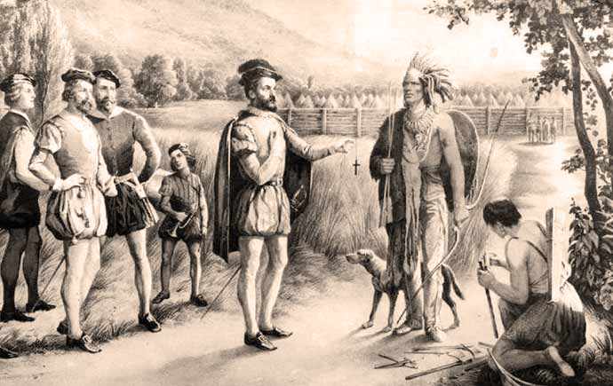
Jacques Cartier meeting with the Hochelagans – 19th century lithograph – Image: Public Domain
Some even attribute his landing place not on the Island of Montreal at all but suggest it was on Île Jésus – the 2nd largest island in the Hochelaga Archipelago – sometimes mistakenly referred to today as the island of Laval, which is understandable since the City of Laval now occupies most of it, but what they probably don’t know, or realize, is there are three small islands further up the Mille Îles river that are called Ies Îles de Laval, or the Laval Islands, so the “Laval” nomenclature has already been used for them. Archeologists still hold out hope that one day the exact site of the village of Hochelaga might be uncovered, so that particular dispute might, at least, be laid to rest… or not.
Why “our mountain” is important to us
Some cities are built around and on hills or mountains; others are built on islands. Montreal belongs to a select few that are constructed on both an island and on a mountain (Hochelaga, Hong Kong, Honolulu, etc).
To Montreal islanders, Mount Royal helps define our sense of home. It’s the soul of our city and the place we lay to rest a multitude of souls from our city who have passed on. For most island residents, it’s where we first take our visitors to give them a “bird’s eye view” of our city. And most of us (take a look at the online petition numbers to confirm this), well, we drive there, however much Projet Montréal might wish us to walk, or take public transport, or pedal up there on our bikes.
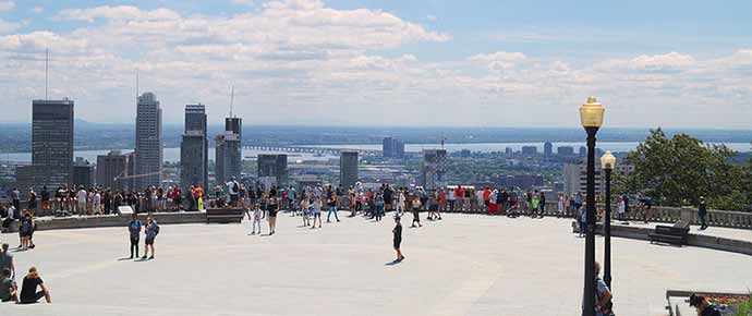
Mount Royal Belvedere for a “bird’s eye view” of the city – Image: Kakurady via StockPholio.net
“I am a cyclist, and I don’t own a car. However, I am against the blocking of transiting traffic on Camilien Houde and Remembrance Road. Firstly, I never go up there by bike, the road incline is far too steep. When I have friends visiting Montreal, I drive them up it (using Communauto) to view the various aspects of Montreal from the Belvedere Camilien Houde, then parking in order to walk to the Mountain Chalet and the Cross. Then we get back in the car to cross over to visit the Summit Circle Belvedere in Westmount, as well as St Joseph’s Oratory. I also go from time to time to what I call the Chalet parking (at Beaver Lake), so I can walk the park trails. I have never ever seen any traffic moving too fast, or overloading these roads. Never. Plus, it’s only a handful of people who adventure up and down it by bike: those who are training for serious cycling competitions. So I ask, why are you cutting off access to the most picturesque road in Montreal in order to eventually rework it (at what cost?) for bicycles, and for the sole use of a few dozen elite sport cyclists at best?”
Gabriel Rouette, June 4, 2018
The only city in the world where the sun “rises in the south”
Before delving further into the conundrum of why Montreal City Hall wants to close off Mount Royal to transiting traffic and in the process bonify the cycling communities over all others, a small aside on the question of orientation, since some news reports are confusing in their description of how traffic travels over the mountain.
For the purposes of this article I am sticking with local convention and terminology that has people and traffic going from east to west and vice versa. For in Montreal we use “our” river and “our” mountain as cardinal points, in giving directions, and in following directions. And as the saying goes… when in Rome… so for our purposes it’s been adapted to, “When in Montreal, do as the Montrealers do”.
“When you are downtown, the St Lawrence River is ‘south’ and Mount Royal is ‘north’; making the West Island and the East End correct in both their names and orientations. The dividing line between ‘east’ and ‘west’ downtown is the boulevard Saint-Laurent. In downtown, streets slope up ‘north’ toward Mount Royal. This local compass tends to confuse visitors because the ‘East’ End is really to the north and the ‘West’ Island is to the south, and the St Lawrence River runs almost northeast-southwest at this location. Most local maps use this convention as do the highways around the city. For example, Autoroute 15 north actually runs northwest and Autoroute 40 east runs northeast. To underscore this fact, a Montreal map will show that the ‘south end’ of Victoria Bridge is in fact further north than the ‘north end’.”
Wikitravel, Montreal
Only in Montréal… as yet another hackneyed phrase pronounces
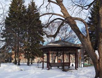
Until this recent restriction on road use, Mount Royal Park was also a place for all seasons. All of seasons of life, that is. When some of us were very young it might have been the first place we learned the joys of tobogganing, or skiing, snow-boarding, or skating, being treated to a hot chocolate to warm up, or else our parents pushed us up Olmstead Road in our stroller (as we later did with our own child or children) to picnic, run around, float our makeshift boats, or perhaps go for a boat ride on Beaver Lake.
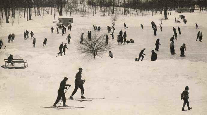
Skaters and skiers enjoying Beaver Lake on Mount Royal c 1935 – Image: Harry Sutcliffe/McCord Musem)
Later as adolescents and adults, we hiked, or jogged, or some of us rode our bikes, up and down its many trails. It was the place we always brought out-of-town family and visitors, and/or we later brought our own families to introduce them to the joys of “our” mountain, and to the veritable “soul” of our city.
“I like to bike on the mountain, but as a new father, getting the baby around is easier by car. To cross the mountain, when you have a kid, it’s much more simpler that way.”
Victor Rodrigue, Côte-des-Neiges, CBC News, May 11, 2018
As we got older, and our bodies less able, we possibly used less and less of the mountain park pathways, steps and trails themselves but we did use the road as a way to access the cemeteries to visit our friends and loved ones, to grieve and to remember. We also perhaps stopped enroute at the Smith House cafe for a coffee and a snack, or sat by Beaver Lake and chatted about old times, or enjoyed the folk dancing on a summer evening.
‘With old age comes a variety of health issues… which means the car is our preferred and to some of us, our necessary and only method of getting around.’
However, many of us as we aged, used our car to take us there as public transport from where we lived meant far too many buses and far too much time spent travelling. With old age comes a variety of health issues, including chronic fatigue syndrome, which means the car is our preferred and to some of us, our necessary and only method of getting around.
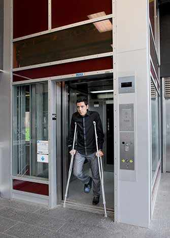
For disabled persons, no matter what age they are, travelling easily around this city is only truly possible by car or van, or sometimes taxis, as the STM disabled bus service means many hours spent waiting to be picked up and no ad hoc, “spur of the moment” journeys as space has to be booked well in advance, so schedules can be drawn up.
When will Montreal make accessibility for all its citizens a priority?
Québec and Montréal’s attitude to its disabled and aging population is nothing short of scandalous. Montreal has a relatively “young” metro, with planning and construction beginning in 1960 and an opening in time for Expo 67; and especially when compared to the extensive systems that existed in London and Paris, and even Moscow, all much older than ours is.
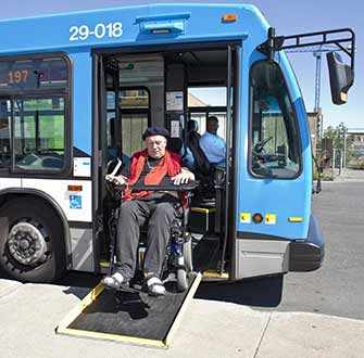
Wheelchair access ramp on STM bus – Image: STM
Yet 50 years ago, Montreal City planners certainly paid no heed to the needs of their disabled (of all ages) and older citizens and that attitude seems to reign on even well into the 21st century at Montreal City Hall. We like to tell ourselves we have a world class city, yet we have so few access points in our metro to accommodate the disabled, older persons and parents with children (only 13 elevators currently in the metro and all of them on the Orange line, although a few more are in the planning stages). And it’s much too costly and also seemingly “impossible” to retrofit some stations, according to the STM.
Up till now one wonders, why only elevators on the Orange line? What if we want to go to another part of the city? “Tough luck”, seems to be the reply, “You’ll have wait around for a bus with space” and, of course, a ramp that works, which they often don’t, especially in winter, due to ice and snow banks. Tough indeed also because most buses only have one space for a wheelchair and what if we are travelling with a friend, also in a wheelchair? The new articulated buses do have space for two wheelchairs, but if you’re three persons, you’re out of luck… you have to wait around for another bus. Plus those new buses aren’t on every route. Being disabled in Montreal means a great deal of advance planning and waiting around, or simply giving up and remaining stuck where we live.
Québec even built a brand new multi-billion dollar hospital centre (the MUHC-Glen site) without working with Montreal and the STM to factor in the need, or provide funds to construct disabled access from the neighbouring Vendôme multi-modal (bixi/bus/metro/train) station, still one of the many without an elevator, even though it’s on the Orange line.
Metro elevator – Image: STM
For what great planning reason was it deemed more important for Snowdon station to get its elevator before Vendôme? No one could even explain quite why. “No money in the budget”, said the STM when quizzed on it, but why was that a response for why Snowdon before Vendôme? “Not my responsibility”, said all the other various parties (Transport Québec, City of Montréal, SNC-Lavalin, MUHC, etc.) present at the Neighbourhood Liason committee that ran for five or so years while the hospital was being constructed and when the subject was raised by concerned citizens on many occasions.
That grievous lack of critical infrastructure planning is now finally being rectified, due to a public outcry, but since work on it only began in October 2017, two and a half years after the hospital centre had opened in May 2015, it will take until the winter of 2020 (provided it is completed on schedule, not always a given) before the station platforms are accessible to the sick, the disabled, the old and parents/grandparents with young children in strollers. Meanwhile the disabled have to take a bus from Lionel-Groulx, the nearest station equipped with elevator access and adding to their journey length yet again.
‘Being disabled in Montreal means a great deal of advance planning and waiting around, or simply giving up and remaining stuck where we live.’
And when the STM embarks on an expensive refurbishing project of individual stations e.g. the recently announced 80-million dollar refurbishment of the Green line’s Beaudry metro station (which isn’t exactly chump change, is it?), we are told, “No, the amount doesn’t include disabled access that would have been too costly”. Why spend 80 million and still have an inaccessible station? Obviously new paint and tiles are more important than the disabled, the elderly, and parents with children are to the STM. “Only in Montreal” indeed!
Montréal and Mont Royal for all citizens, not merely the fit and able
This, and other actions by City Hall, tell us that this is a city still being “designed and run” for those who are younger and able-bodied, as demonstrated by Projet Montréal’s heavy-handed promotion of “active transportation”, especially as far as our namesake park access is concerned.
Thus, in spite of protestations to the contrary, their revamped “vision” for Mount Royal Park does little to create accessibility and assist the disabled, and the elderly, or even accommodate families with children in strollers, especially if you are also trying to carry equipment (skates, skis, toboggans, etc.), luggage or heavy shopping/picnic bags on public transportation. And this from a city that wants to attract more families with children? Perhaps start with making the City more accessible to all segments of your population, not just to some.
‘… their revamped “vision” for Mount Royal Park does little to create accessibility and assist the disabled, and the elderly, or even accommodate families with children…’
This is also the message being conveyed with Projet Montréal’s short-sighted closure of Mount Royal’s two roads that run alongside the park between it and the cemeteries, with its now confusing delineation of which vehicles can go where. The old, the disabled, parents, grandparents and the very young, as well as the grief-stricken, certainly aren’t being accommodated in these plans. Predominantly it’s the fit and able-bodied. Have you no compassion for the less able segments of your population, Madame Mayor and Mr Luc Ferrandez? Obviously not. The message comes across loud and clear. Mount Royal Park is primarily for the use of the physically fit and healthy. The rest will have to make do with the little minor bits of the park now so awkwardly accessible to them.
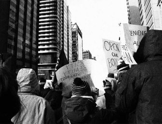
Participate in the public consultation process with the OCPM
By the way, the Office de la consultation publique de Montréal (OCPM), Montreal’s Public Consultation Office has lots of info on-line (much of it, though not all, in English) – scroll down the page to find it. They have also posted the recordings and transcripts from the two public meetings in May. Note: the “English” page on their site is not helpful. It merely tells you to check for English documentation on the French pages… not really helpful if you don’t read French well, but the info is there and if you scroll down the French page you will find it.
Here is the link to the OCPM site where you can have your say (by telephone and/or in writing in either English or French or both). Make the effort to participate. Don’t put it off too long.
Attention! Leaving a note in writing on the OCPM site stating your point of view is incredibly important if we are to have any hope of altering these changes to our mountain access and maintain access for all.
As of Thursday, June 21, the YES to closing Mount Royal are winning the comments battle on the OCPM site, with a overall total of 779 participants leaving a comment, of which 574 are supporting the road closure and only 118 are against. You’ll notice those numbers don’t tally (i.e. don’t add up to 779), so I am wondering what the issue is? i.e. what do the missing 87 people think? Are they neutral? If so, the OCPM should create a column to let us know that.
‘… there are far more of those participating in the on-line comment process that are seemingly in favour of blocking through traffic.’
Nevertheless, and until they get that sorted out, it still means there are far more of those participating in the on-line comment process that are seemingly in favour of blocking through traffic. So, if you want your mountain road to go back to allowing transiting traffic, can I suggest you take the time to let the OCPM know your feelings about the road closures.
And in case, you’re not sure what to say. Why not spend a few minutes scrolling through other people’s comments, they may give you some ideas about how to word your own comment. Nothing prevents you from leaving a written comment, or comments now, as well as “voting” on a variety of confusing options (truly at first glance they couldn’t have made it more confusing and complicated as they seemingly have managed to do) as well as signing up to give a comment in person later (as your verbal statement will only be taken once the pilot project is over).
Right now to win the online “hearts and minds” battle, can I suggest you state you preference loud and clear, by leaving a written comment clearly indicating your wishes. Yes, the process initially appears somewhat complicated, but there is help and the OCPM does get back to you with assistance.
There is also an online survey you can answer but be warned it’s not available in English and once you do answer your access to it is blocked, which I found out when I went back on the OCPM site to review the questions. I guess that’s to stop people answering a multiple of times, so be warned.
Not sure if that also blocks computers at public libraries for only one usage too, so I am not sure where that puts households with only one computer, yet two or more users as it erroneously presumes everyone has their own personal computer or tablet connected to the internet, which is not always the case.
May 2018 public information meeting transcripts are posted
The OCPM has also posted the information session recordings along with written transcripts from the two public meetings in May. Once again only in French but I found them very informative. Their documentation list can be accessed here.
Note: the “English” section accessed from the top row of “buttons” and marked ENG on their site is not helpful, unless you want to know more about the OCPM and the other past and public consultations they had, or are engaged in. Unfortunately it merely tells you to check for English documentation on the French pages! The link to the English contact you need is here.
Participate via the OCPM or, if that doesn’t appeal simply sign the petition signalling your discontent with this move by Projet Montréal.
However, I would encourage you to avail yourself of all and every option if you can. Even though several of Projet Montréal’s “improvements” to Mount Royal Park appear very permanent in nature (pun intended), and it may mean this misguided attempt at forcible social engineering could remain on our mountain for a long time to come, it is still worth reading up on and participating in the consultation process with the OCPM.
Further information on the process and to download documentation, click here.
Public meeting in Westmount
Mayor Plante promised Christina Smith, Mayor of Westmount that a public meeting, or rather a Round Table discussion (whatever that means) would be held in Westmount, so Westmounters and potentially other English speakers from NDG for instance, could provide their input and feedback.
Hopefully it will accommodate English speakers from anywhere on Montreal Island, along with those more comfortable expressing themselves in English. It has recently been reported in the Westmount Independent that this will happen on September 12, 2018 at Victoria Hall, 4626 Sherbrooke W. No further details as yet, since Mayor Smith explained it is Montreal who is organizing it, consequently they have to wait for them to furnish additional details.
Coming soon
Sign-up for Part 2 of A Tale of Two Cities coming soon in WestmountMag.ca.
About the ALCC Living History Collection
‘The road of life twists and turns and no two directions are ever the same. Yet our lessons come from the journey, not the destination.’
Don Williams, Jr
Do you have a story and memories of your times passing over the mountain and/or visiting Mount Royal Park and/or its adjacent conjoined cemeteries that you would like to share? If so, the Atwater Library Living History team would like to hear from you. Please contact Eric Craven, Atwater Library Community Outreach Librarian at dlp@atwaterlibrary.ca
For those interested in further info on the background and rationale of the Living History Collection see: Birth of a Local Living History Collection – Part 1 and Part 2.
And to access all the WestmountMag.ca series of articles on the Atwater Library’s new Living History Collection simply click here.

Feature image: Downtown Montreal, aerial view from above Mount Royal Chalet (on the left) to the St Lawrence and the South Shore – John Lian (CC BY-SA 4.0 ), from Wikimedia Commons

Wanda Potrykus is a writer, editor, translator and poet. A graduate of McGill, she has spent most of her career in marketing communications, PR, event and media relations specializing in international aviation, telecommunications, education and the marketing of the arts.
info@westmountmag.ca

 January 9, 2026" />
 through digital innovation" />
 looks back at 2025" />
 online betting rules?" />
 a film by Andrés Livov" />
 for its 16th edition" />
 Passion fruit meringue verrine" />
 playful clownish escapade" />
 World rhythms on stage" />
 management mistakes" />
 Kensington Avenue" />
 Vegan Chili Chocolate Cake" />
 Bethune tunnel" />
 Left out of breath" />
 of business strategy" />
 damage before it starts" />


 into a professional career" />

 plumbing issues at home" />
 embraces bold cinema" />
 Red snapper papillote" />
 the Legend of Pepita" />
Thank-you for this really well-researched and informative article, so timely given the proposals to shut down access. I will definitely use this article when I am next permitted to teach my graduate seminar on public landscapes in Montreal! I fully agree that the proposed closure is unjust and excludes many of the people to whom the Mountain matters most. Petition signed – thank-you for these really helpful links and information. I would love to share my Mont-Royal stories too.
A wonderful article Wanda.
Well – researched and beautifully and poignantly written. I would hope that those of our fellow citizens who are cyclists resist this unpleasant attempt to pit us against each other when really we can all use and enjoy Mont Royal without infringing on other’s rights to access.
Great article. More?
Pat Pang